-
[[category:QGIS Tutorial]]
2 members (0 subcategories, 0 files) - 11:38, 17 September 2014
-
{{Content Tree|HEADER=QGIS Tutorial|NAME=QGIS tutorial}}
547 B (76 words) - 12:39, 17 February 2011
-
[[category: FAQ (QGIS Tutorial)]]
692 B (115 words) - 14:37, 16 September 2014
-
[[File:Nodata_example.jpg|thumb|600px|center|A rastermap in QGIS. The white space where the mouse points at indicates a nodata area. The ope
In [[QGIS]], information on the nodata value can be obtained from the layer propertie
1 KB (207 words) - 14:36, 16 September 2014
-
[[Category:QGIS Tutorial]]
1 member (0 subcategories, 0 files) - 09:54, 18 October 2017
-
[[category: FAQ (QGIS Tutorial)]]
464 B (67 words) - 14:35, 16 September 2014
-
...ating one or several spectral indices at the same time can be found in the QGIS processing toolbox.
[[Category:QGIS Tutorial]]
3 KB (466 words) - 17:03, 14 June 2021
-
<tr><td style="white-space: nowrap; padding: 0.5em">'''Part of the [[QGIS tutorial]]'''</td></tr>
488 B (68 words) - 13:15, 25 March 2011
-
==QGis Tutorial==
*Upload of other file formats: PDF? Course data for QGis tutorial?
1 KB (181 words) - 13:24, 18 March 2011
-
[[category:QGIS Tutorial]]
6 members (0 subcategories, 0 files) - 11:37, 17 September 2014
-
[[Category:QGIS Tutorial]]
3 members (0 subcategories, 0 files) - 11:30, 17 September 2014
-
==QGIS tutorial==
*template for QGIS version on every tutorial page? How to do this?
2 KB (292 words) - 13:25, 8 September 2011
-
* The [[QGis tutorial]]
1,021 B (136 words) - 16:52, 14 September 2011
-
#redirect [[QGIS tutorial]]
27 B (3 words) - 13:20, 10 September 2011
-
* What to do with the [[QGIS tutorial]] articles in the [[:category:Image classification]]? [[User:Lburgr|- Leven
620 B (84 words) - 14:46, 18 June 2013
-
=== Quantum GIS Tutorial ===
;Tutorial basics
4 KB (355 words) - 12:30, 2 April 2013
-
#redirect [[QGIS tutorial]]
27 B (3 words) - 07:18, 4 May 2012
-
#redirect [[QGIS Tutorial 2013/14]]
35 B (3 words) - 13:13, 11 November 2013
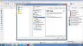 | File:RemSens Exercise02 1.png QGIS Screenshot with opened plugin manager. Part of [[QGIS Tutorial 2013/14]] exercise 02.
(1,366 × 768 (181 KB)) - 13:16, 16 November 2013 |
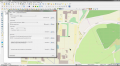 | File:RemSens Exercise02 2.png ...and open attribute table of a GPX layer. Part of exercise 02 of the [[QGIS Tutorial 2013/14]].
(1,928 × 1,058 (537 KB)) - 08:43, 29 October 2014 |

