-
...rst step is to converting the pixel value to radiance, in case of Rapideye images the equation is (RapidEye Standard Image Product Specifications
For Rapideye images Ai is 1/100 (RapidEye Standard Image Product Specifications, 2010, Haque et
5 KB (774 words) - 12:51, 21 October 2013
-
|#default=Protected<!--fallback value-->}} images|{{PAGENAME}}]]}}}}}}}</includeonly><noinclude>
3 KB (330 words) - 16:59, 4 November 2010
-
remotely sensed images in a manner that makes different ''thematic classes'',
14 KB (2,189 words) - 06:54, 11 October 2013
-
Aerial photographs or satellite images are used to measure the [[Ancillary variable|ancillary variable]], for exa
2 KB (324 words) - 15:17, 26 October 2013
-
...tial because sometimes, it is hard to distinguish the land use system from images without knowing the area well: grassland with trees may be forest (if the c
12 KB (1,873 words) - 08:02, 28 October 2013
-
...ide of the [[Tree definition|tree]]. For measuring the diameter, these two images must coincide. That means that the left side of the trunk in the direct and
3 KB (450 words) - 13:12, 27 October 2013
-
[[Category:Downloading satellite images]]
2 KB (267 words) - 10:40, 25 October 2019
-
...ginal 41 Landsat scenes are taken as population. However, when these 41 images are simply 30 times copied (thus generating a much larger population but
... the Bolivia data. The 10% sample, where 4 images were taken out of the 41 images covering Bolivia, was repeated many times. The resulting sample distributio
5 KB (752 words) - 08:59, 28 October 2013
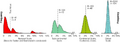 | File:3.7-fig44.png ...original 41 Landsat scenes are taken as population. However, when these 41 images are simply 30 times copied (thus generating a much larger population but wi
(859 × 304 (767 KB)) - 22:27, 9 March 2011 |
-
## Select the input folder containing your images.
2 KB (273 words) - 10:50, 29 October 2014
-
:A geometric transformation that scales, rotates, skews, and/or translates images or coordinates between any two Euclidean spaces. It is commonly used in GIS
...nd blue or green. When viewed through filters of corresponding colors, the images appear as one three-dimensional image.
6 KB (966 words) - 10:45, 16 January 2014
-
*Implement changing images on community portal (http://www.mediawiki.org/wiki/Extension:Javascript_Sli
2 KB (314 words) - 13:28, 13 May 2013
-
... angles and combinations with other spatial information by integrating the images into a geographic information system (GIS) is not ad hoc possible. Conseque
...per left pixel or at the upper left edge of that pixel. For multi-spectral images a third index <math>b</math> is introduced to represent the number of bands
12 KB (1,781 words) - 11:49, 30 September 2020
-
.... Remote sensing data (digital aerial photographs, [[RapidEye]] satellite images) play a central role in the derivation of area-wide estimations in form of
3 KB (369 words) - 14:49, 27 February 2014
-
...This will involve a variety of remote sensing products including [[aerial images]], RapidEye and TerraSAR-X data. Different segmentation and classification
5 KB (741 words) - 09:29, 15 October 2013
-
... improve and develop new methods to identify ToF resources from satellite images at different geometric, spatial and [[radiometric resolution]]s. In this c
2 KB (239 words) - 16:30, 7 December 2012
-
[[Category:05 Digital images]]
65 B (5 words) - 14:33, 10 December 2012
-
[[Category:05 Digital images]]
66 B (5 words) - 14:33, 10 December 2012
-
For others to better understand your work, it's good to use images of what happens on screen,
3 KB (508 words) - 15:29, 11 December 2013
-
=Split multiband image into several raster images=
SAGA's Region Growing Algorithm works only with single band images. Therefor, we have to split our multiband image into its individual bands f
10 KB (1,669 words) - 12:21, 21 February 2019