BEST IO-H2
(Created page with " '''Project Title:''' BEST Subproject IO-H2 *'''Funding:''' BMBF *'''Duration:''' 2011-2014 *'''Link:''' [http://www.best-forschung.de www.best-forschung.de] *'''Coordi...") |
|||
| (6 intermediate revisions by one user not shown) | |||
| Line 1: | Line 1: | ||
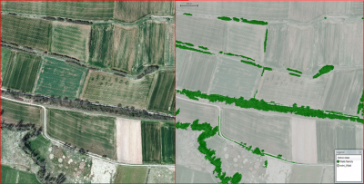
| − | + | [[file:Best1.png|thumb|right|400px|Detection of wood resources outside forest in aerial photographs based on object orientated image classification (supervized classification) using eCognition (Trimble, Germany).]] | |
'''Project Title:''' BEST Subproject IO-H2 | '''Project Title:''' BEST Subproject IO-H2 | ||
| Line 8: | Line 8: | ||
*'''Link:''' [http://www.best-forschung.de www.best-forschung.de] | *'''Link:''' [http://www.best-forschung.de www.best-forschung.de] | ||
| − | *'''Coordination:Prof. Dr. Christoph Kleinn | + | *'''Coordination:''' Prof. Dr. Christoph Kleinn |
| − | *'''Project researcher:''' Dominik Seidel (Postdoc)) | + | *'''Project researcher:''' Dominik Seidel (Postdoc) |
| + | |||
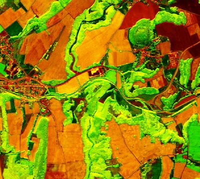
| + | [[file:Best_Rapideye.jpg|thumb|right|400px|Color composite (NIR and RedEdge) of a RapidEye satellite image.]] | ||
==Background== | ==Background== | ||
Studies focusing on the estimation of biomass potentials of wood outside forests (WOF), such as hedges, groves or bushes are rare. Scarcity of the study objects themselves and large variability of their biomass potential might be reasons why they have not been studied intensively so far. Research was limited to rather small areas in the past and reliable data on biomass potentials on the landscape level, especially information on the biomass density of WOF and their dynamics is rare. | Studies focusing on the estimation of biomass potentials of wood outside forests (WOF), such as hedges, groves or bushes are rare. Scarcity of the study objects themselves and large variability of their biomass potential might be reasons why they have not been studied intensively so far. Research was limited to rather small areas in the past and reliable data on biomass potentials on the landscape level, especially information on the biomass density of WOF and their dynamics is rare. | ||
Methods for the detection of WOF and an estimation of the biomass on the landscape scale based on adapted, sample based inventories do not exist. Widely used volume and biomass models developed for forests cannot be used for WOF due to differences in the growth pattern. Therefore inventory designs have to be modified and adapted to the woody resources outside forest. | Methods for the detection of WOF and an estimation of the biomass on the landscape scale based on adapted, sample based inventories do not exist. Widely used volume and biomass models developed for forests cannot be used for WOF due to differences in the growth pattern. Therefore inventory designs have to be modified and adapted to the woody resources outside forest. | ||
| + | |||
==Project Goals== | ==Project Goals== | ||
The project aims to: | The project aims to: | ||
| − | *develop adapted inventory designs for a sample based detection of existing WOF resources along with an assessment of the landscape potential for new areas where WOF can be established for | + | *develop adapted inventory designs for a sample based detection of existing WOF resources along with an assessment of the landscape potential for new areas where WOF can be established for bio-energy purpose, |
| − | *monitor the dynamics of WOF based on the implementation of a permanent set of sampling locations (repeated inventory),*estimate the mean biomass densities for different types of WOF (such as hedges, groves, single trees etc.), | + | *monitor the dynamics of WOF based on the implementation of a permanent set of sampling locations (repeated inventory), |
| + | *estimate the mean biomass densities for different types of WOF (such as hedges, groves, single trees etc.), | ||
*integrate aerial information from remote sensing data (RapidEye), aerial photographs, and terrestrial inventories in order to create maps of biomass potentials of WOF. | *integrate aerial information from remote sensing data (RapidEye), aerial photographs, and terrestrial inventories in order to create maps of biomass potentials of WOF. | ||
| + | |||
| + | |||
| + | |||
| + | [[Category:Projects]] | ||
Latest revision as of 07:57, 27 March 2013
Project Title: BEST Subproject IO-H2
- Funding: BMBF
- Duration: 2011-2014
- Link: www.best-forschung.de
- Coordination: Prof. Dr. Christoph Kleinn
- Project researcher: Dominik Seidel (Postdoc)
[edit] Background
Studies focusing on the estimation of biomass potentials of wood outside forests (WOF), such as hedges, groves or bushes are rare. Scarcity of the study objects themselves and large variability of their biomass potential might be reasons why they have not been studied intensively so far. Research was limited to rather small areas in the past and reliable data on biomass potentials on the landscape level, especially information on the biomass density of WOF and their dynamics is rare. Methods for the detection of WOF and an estimation of the biomass on the landscape scale based on adapted, sample based inventories do not exist. Widely used volume and biomass models developed for forests cannot be used for WOF due to differences in the growth pattern. Therefore inventory designs have to be modified and adapted to the woody resources outside forest.
[edit] Project Goals
The project aims to:
- develop adapted inventory designs for a sample based detection of existing WOF resources along with an assessment of the landscape potential for new areas where WOF can be established for bio-energy purpose,
- monitor the dynamics of WOF based on the implementation of a permanent set of sampling locations (repeated inventory),
- estimate the mean biomass densities for different types of WOF (such as hedges, groves, single trees etc.),
- integrate aerial information from remote sensing data (RapidEye), aerial photographs, and terrestrial inventories in order to create maps of biomass potentials of WOF.

