Haralick Texture
| Line 12: | Line 12: | ||
of one. At first we need to linearly transform the 16-bit ASTER data to 8-bit radimetric | of one. At first we need to linearly transform the 16-bit ASTER data to 8-bit radimetric | ||
resolution. | resolution. | ||
| + | |||
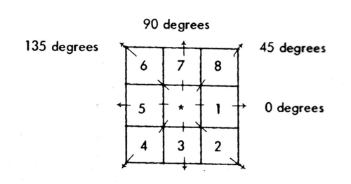
| + | [[File:Texture.png|center|500px|thumb|3x3 window definition and spatial relationship for calculating Haralick texture measures. Pixel 1 and 5 are 0o (horizontal) nearest neighbors to the center pixel * ; pixel 2 and 6 are 135o nearest neighbors; pixels 3 and 7 are 90o nearest neighbors, pixel 4 and 8 are 45o nearest neighbors to the center pixel * (Haralick et al. 1973)]] | ||
{{Exercise|message=Exercise 35|text=}} | {{Exercise|message=Exercise 35|text=}} | ||
Revision as of 16:23, 2 January 2011
Image texture is a quantification of the spatial variation of grey tone values. Haralick et al. (1973) presented texture measures that may be derived by comparing the values of the digital numbers within a window. An essential component of the concept of the Haralick texture measures is the definition of eight nearest-neighbor resolution cells (Fig.). Now we may define different matrices for different angles (0o,45o,90o,135o) and distances between the horizontal neighboring pixels. Many studies in land cover and forest type classification utilize textural features to improve the classifcation accuracies. We use the ASTER satellite band number 1 (green) and an inter-pixel sampling distance of one. At first we need to linearly transform the 16-bit ASTER data to 8-bit radimetric resolution.

