Image fusion
From AWF-Wiki
Pansharpening of Sentinel-2 requires defining a 10m reference band because there is no panchromatic band as for Landsat available. One option is a selection among the 10-m bands (B2, B3, B4 or B8) or a synthesis (e.g. weighted average of 10-m bands). Following the latter approach, luminance can be calculated from Blue, Red, Green and NIR band to receive a single band grey scale image.
Create a synthesis panchromatic band
- Load the input image
- Open the raster calculator and apply the following luminance formula: Y = 0.20 * NIR 0.15 * Red + 0.58 * Green + 0.07 * Blue
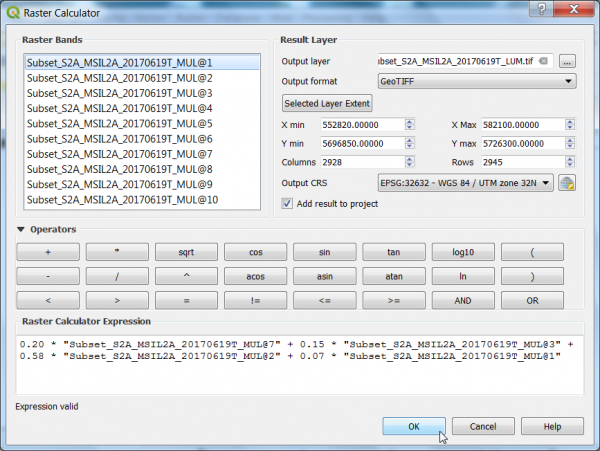

- Define path and name for the output layer
- Click on the ‘OK-button’.
Create a pan-sharpened layer
Does currently not work in Plugin for QGIS 3.4. Use OTB standalone.
- Search for Pansharpening (Bayes) algorithm in the Processing Toolbox.
- Select pseudo-panchromatic band as the Input PAN Image.
- Select the layer stack with the original 20m bands as the InputXS Image. Therefore (1) Follow Split stack to extract the 20m Bands (additional creation parameters: :-b 5 -b 6 -b 7 -b 9 -b 11 -b 12) from the multiband file creating at the same time a new multiband file.
- Specify the directory to save the output file and click on the ‘Run-button’.
Compare the fused image with the original image

