Forest boundary

When defining forest, one must also define where forest ends; forest edge or forest boundary is the imagined line that separates forest and non-forest. The question of a clear definition of the forest boundary is particularly difficult in transition areas between forest and non-forest where a dense forest is gradually opening up to tree-free land, as for example at the timber line or at the boundary of deserts (Kleinn 2007[2]).
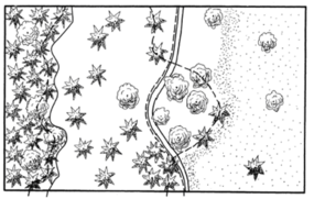
Even if there is an abrupt change from forest to, for example, agriculture, one must still define whether the vertical projection of the crowns is the forest boundary (that is relatively easy to determine from aerial photographs) or the connecting line between the stems at the forest edge (that is easily be done in the field). Figure 1 illustrates various options.
In particular in highly fragmented forested landscapes, where the length of the forest boundary is considerable, the question of definition of forest boundary is important; different definitions can considerably alter the forest cover estimates: if the crown projection is taken as forest boundary, the forest area will be larger compared to a forest boundary that goes along the connecting line between border stems.
Again, there is no “right” or “wrong” definition, but only “clear” and “not-clear” definitions. There are only few forest inventories that contain a clear and operational definition of where the forest boundary exactly is.
References
- ↑ Kenneweg, H. 2002. Neue methodische Ansätze zur Fernerkundung in den Bereichen Landschaft, Wald und räumliche Planung. In: Dech S et al. (Hrsg.): Tagungsband 19. DFD-Nutzerseminar, 15.-16. Okt. 2002, S. 127-137.
- ↑ Kleinn, C. 2007. Lecture Notes for the Teaching Module Forest Inventory. Department of Forest Inventory and Remote Sensing. Faculty of Forest Science and Forest Ecology, Georg-August-Universität Göttingen. 164 S.