File:ConstellationGPS.gif
From AWF-Wiki
No higher resolution available.
ConstellationGPS.gif (240 × 192 pixels, file size: 485 KB, MIME type: image/gif, looped, 300 frames, 30 s)
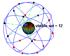
A simulation of the original design of the GPS space segment, with 24 GPS satellites. Originally uploaded on wikipedia
File history
Click on a date/time to view the file as it appeared at that time.
| Date/Time | Thumbnail | Dimensions | User | Comment | |
|---|---|---|---|---|---|
| current | 16:49, 14 April 2011 | | 240 × 192 (485 KB) | Lburgr (Talk | contribs) | A simulation of the original design of the GPS space segment, with 24 GPS satellites (4 satellites in each of 6 orbits), showing the evolution of the number of visible satellites from a fixed point (45ºN) on earth (considering "visibility" as having dire |
- Edit this file using an external application (See the setup instructions for more information)
File usage
There are no pages that link to this file.