Search results
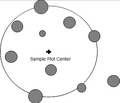
File:4.2.2-fig46.png ...s sample trees that are within a defined distance (radius) from the sample point, which constitutes the plot center.(361 × 311 (330 KB)) - 07:34, 3 March 2011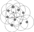
File:4.2.2-fig47.png ... Those trees are taken as sample trees in whose inclusion zones the sample point comes to lie.(436 × 406 (520 KB)) - 07:35, 3 March 2011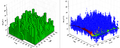
File:4.8-fig70.png ... value of which is determined by the surrounding trees (sample plot). Each point has a value which is here indicated through the cloud of points; in additio(816 × 328 (786 KB)) - 20:45, 9 March 2011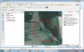
File:RemSens Exercise06 04.png ...shot of [[QGIS]] 2.0 session with loaded Google satellite layer and sample point for landscape classification.(1,280 × 800 (712 KB)) - 17:08, 24 January 2014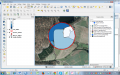
File:RemSens Exercise06 05.png ...of [[QGIS]] 2.0 session with Google satellite layer and a digitized sample point with landscape classes.(1,280 × 800 (648 KB)) - 17:11, 24 January 2014


