Search results
File:RemSens Exercise02 1.png QGIS Screenshot with opened plugin manager. Part of [[QGIS Tutorial 2013/14]] exercise 02.(1,366 × 768 (181 KB)) - 13:16, 16 November 2013
File:RemSens Exercise02 2.png ...and open attribute table of a GPX layer. Part of exercise 02 of the [[QGIS Tutorial 2013/14]].(1,928 × 1,058 (537 KB)) - 08:43, 29 October 2014
File:RemSens Exercise02 3.png Screenshot of the ''eVis Event Browser'' in [[QGIS]] 2.0. Part of the [[QGIS Tutorial 2013/14]] exercise 2.(1,928 × 1,058 (917 KB)) - 08:41, 29 October 2014
File:RemSens Exercise01 1.png ...e01 of the [[QGIS Tutorial 2013/14]], after loading a ''landsat'' map into QGIS.(1,277 × 1,002 (951 KB)) - 10:15, 9 November 2013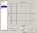
File:RemSens Exercise01 2.png ...am of pixel values of a ''landsat'' map, generated in the course of [[QGIS Tutorial 2013/14]], Exercise 01.(875 × 772 (56 KB)) - 17:09, 9 November 2013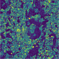
File:RemSens Exercise01 3.png ...d 1 map displayed in pseudocolor in QGIS. Part of exercise 1 of the [[QGIS Tutorial 2013/14]].(662 × 664 (1.02 MB)) - 10:08, 9 November 2020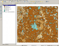
File:RemSens Exercise01 4.png ...ap for Göttingen and vicinity in QGIS. Part of exercise one of the [[QGIS tutorial 2013/14]].(1,276 × 999 (630 KB)) - 18:01, 9 November 2013
File:RemSens Exercise03 1.png ...ogue of the ''merge'' tool from the ''processing toolbox''. Part of [[QGIS tutorial 2013/14]] [[Exercise 03: Georeferencing]].(1,826 × 870 (368 KB)) - 08:21, 2 May 2016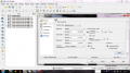
File:RemSens Exercise03 2.png ...er properties dialogue opened for a multiband raster image. Part of [[QGIS tutorial 2013/14]] [[Exercise 03: Georeferencing]].(1,366 × 768 (313 KB)) - 15:35, 8 December 2013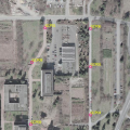
File:RemSens Exercise03 4.png ... used for georeferencing in [[Exercise 03b: Georeferencing]] of the [[QGIS tutorial 2013/14]].(530 × 530 (545 KB)) - 17:24, 8 December 2013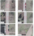
File:RemSens Exercise03 5.png ...rol points (GCP's) used for [[Exercise 03b: Georeferencing]] of the [[QGIS tutorial 2013/14]].(801 × 864 (2.65 MB)) - 18:03, 8 December 2013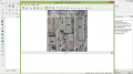
File:RemSens Exercise03 6.png ...ing dialogue. Part of [[Exercise 03b: Georeferencing]], part of the [[QGIS tutorial 2013/14]].(1,366 × 768 (526 KB)) - 10:15, 10 December 2013
File:RemSens Exercise03 7.png ...ferencing dialogue. Part of [[Exercise 03b: Georeferencing]] of the [[QGIS tutorial 2013/14]].(491 × 194 (373 KB)) - 10:32, 10 December 2013
File:RemSens Exercise07 01.png ...Means image classification plugin dialogue in [[QGIS]] 2.0. Part of [[QGIS Tutorial 2013/14]].(658 × 484 (25 KB)) - 10:18, 17 February 2014
File:RemSens Exercise07 02.png ...ed K-Means image classification plugin in [[QGIS 2.0]]. Part of the [[QGIS Tutorial 2013/14]](800 × 711 (375 KB)) - 10:19, 17 February 2014
File:RemSens Exercise07 03.png ...-Toolbox in [[QGIS]], 2.0 displayed in discrete colors. Part of the [[QGIS Tutorial 2013/14]].(800 × 711 (223 KB)) - 10:21, 17 February 2014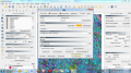
File:RemSens Exercise08 01.png ...Semi-Automatic Classification'' plugin in [[QGIS]] 2.0. Part of the [[QGIS Tutorial 2013/14]].(1,366 × 768 (551 KB)) - 16:33, 17 February 2014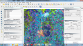
File:RemSens Exercise08 02.png ...on Plugin'' in [[QGIS]] 2.0 with loaded land cover map. Part of the [[QGIS Tutorial 2013/14]].(1,366 × 768 (1.18 MB)) - 16:35, 17 February 2014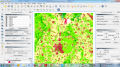
File:RemSens Exercise08 04.png ...cation'' plugin in [[QGIS]] 2.0 with output raster map. Part of the [[QGIS Tutorial 2013/14]].(1,366 × 768 (407 KB)) - 16:36, 17 February 2014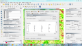
File:RemSens Exercise08 05.png ...Semi-Automatic Classification Plugin'' in [[QGIS]] 2.0. Part of the [[QGIS Tutorial 2013/14]].(1,366 × 768 (306 KB)) - 16:37, 17 February 2014


