Search results
Page title matches
File:Qgis image envelope.png (486 × 677 (49 KB)) - 14:23, 12 November 2018

Page text matches

File:M-en-sidebar.png [[Category:Image]](150 × 345 (6 KB)) - 10:23, 17 December 2008
File:M-en-pagetabs.png [[Category:image]](607 × 30 (5 KB)) - 10:25, 17 December 2008
File:M-en-userlinks.png [[Category:image]](510 × 20 (4 KB)) - 10:26, 17 December 2008
File:Tree coordinates.png [[Category:Image]](1,152 × 815 (23 KB)) - 14:30, 21 January 2009
File:Create buffer.jpg [[Category:Image]](600 × 57 (11 KB)) - 07:39, 22 January 2009
File:Buffers.png [[Category:Image]](1,152 × 815 (128 KB)) - 07:42, 22 January 2009
File:Calculategeometry.jpg [[Category:Image]](627 × 314 (75 KB)) - 08:02, 22 January 2009
File:Dissolve.jpg [[Category:image]](598 × 608 (48 KB)) - 08:14, 22 January 2009
File:Jigsaw.png [[Category:Image]](844 × 598 (33 KB)) - 10:28, 3 November 2010
File:K-treejigsaw.jpg [[Category:Image]](626 × 300 (32 KB)) - 12:52, 25 October 2015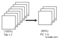
File:Pca.gif Graphic explaining the principal component (PCA) analysis image transformation technique(296 × 193 (4 KB)) - 15:53, 27 October 2010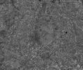
File:Etm40 grey.jpg Fourth band of a LANDSAT image symbolized in grey scale.(997 × 842 (214 KB)) - 11:51, 26 January 2011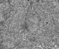
File:Etm40 grey stdev.jpg Fourth band of a LANDSAT image symbolized in greyscale; based on a standard deviaton of 2.5 with stretch t(997 × 842 (267 KB)) - 11:52, 26 January 2011
File:Dilution of precision.png An image of the dilution of precision (DOP) depending on the position of satellites(780 × 348 (40 KB)) - 14:47, 15 April 2011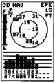
File:Garmin satellite.png An image of the Garmin GPS receivers satellite display(450 × 676 (6 KB)) - 09:51, 23 April 2011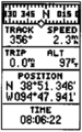
File:Garmin position.png An image of the Garmin GPS receivers position display(418 × 668 (6 KB)) - 10:15, 23 April 2011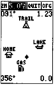
File:Garmin map.png An image of the Garmin GPS receivers map display(422 × 668 (5 KB)) - 10:40, 23 April 2011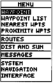
File:Garmin main.png An image of the Garmin GPS receivers main menu display.(410 × 650 (6 KB)) - 13:44, 23 April 2011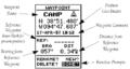
File:Garmin add waypoint.png An image of the Garmin GPS receivers waypoint display with text explaining its compo(928 × 496 (56 KB)) - 13:47, 23 April 2011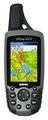
File:GPSMAP60CSx-2-Topo.jpg An image of the Garmin GPSmap 60CSx device. The file was taken from garmin.com, is o(1,000 × 2,500 (1.02 MB)) - 10:03, 25 April 2011


