File:4.2.6-fig52.png
From AWF-Wiki
(Difference between revisions)
(A diagram showing an area of refer-ence and projected area into the map plane on a sloping terrain. Reference: Kleinn C., B. Traub and C. Hoffmann 2002. A note on the slope correction and the estimation of the length of line features. Canadian Journal o) |
|||
| Line 1: | Line 1: | ||
| − | A diagram showing an area of | + | A diagram showing an area of reference and projected area into the map plane on a sloping terrain. |
Reference: | Reference: | ||
Kleinn C., B. Traub and C. Hoffmann 2002. A note on the slope correction and the estimation of the length of line features. Canadian Journal of Forest Research 32(4):751-756. | Kleinn C., B. Traub and C. Hoffmann 2002. A note on the slope correction and the estimation of the length of line features. Canadian Journal of Forest Research 32(4):751-756. | ||
Latest revision as of 09:45, 3 March 2011
A diagram showing an area of reference and projected area into the map plane on a sloping terrain.
Reference:
Kleinn C., B. Traub and C. Hoffmann 2002. A note on the slope correction and the estimation of the length of line features. Canadian Journal of Forest Research 32(4):751-756.
File history
Click on a date/time to view the file as it appeared at that time.
| Date/Time | Thumbnail | Dimensions | User | Comment | |
|---|---|---|---|---|---|
| current | 09:10, 3 March 2011 | 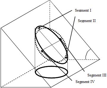 | 360 × 296 (313 KB) | Aspange (Talk | contribs) | A diagram showing an area of refer-ence and projected area into the map plane on a sloping terrain. Reference: Kleinn C., B. Traub and C. Hoffmann 2002. A note on the slope correction and the estimation of the length of line features. Canadian Journal o |
- Edit this file using an external application (See the setup instructions for more information)
File usage
The following page links to this file: