Exercise : Measuring heights of trees outside the forest (TOF) in digital orthophotos (DOP)
(→Digitizing shadow length and measuring sun azimuth in digital orthophotos) |
(→Digitizing shadow length and measuring sun azimuth in digital orthophotos) |
||
| Line 26: | Line 26: | ||
## Install the CadTools plugin using {{mitem|text=Plugins --> Manage and install plugins}}. | ## Install the CadTools plugin using {{mitem|text=Plugins --> Manage and install plugins}}. | ||
| − | ## We use the "Show azimuth" function of CadTools to calculate the azimuth between two points which have to be selected first. Zoom in to the overhead line tower and the digitized shadow lenght. Activate {{button|text=Select 2 Vertex Points}} [[file:QGIS_2.0_Select2Points.png|25px]] and click at first on the node on top of the shadow of the line tower and second on the node near | + | ## We use the "Show azimuth" function of CadTools to calculate the azimuth between two points which have to be selected first. Zoom in to the overhead line tower and the digitized shadow lenght. Activate {{button|text=Select 2 Vertex Points}} [[file:QGIS_2.0_Select2Points.png|25px]] and click at first on the node on top of the shadow of the line tower and second on the node near the base of the line tower. Calculate the azimuth by clicking {{button|text=Show Azimuth}} [[file:QGIS_2.0_ShowAzimuth.png|25px]]. |
==Estimating sun elevation== | ==Estimating sun elevation== | ||
==Calculating individual tree heights== | ==Calculating individual tree heights== | ||
Revision as of 16:09, 15 July 2014
Contents |
Shadows in orthorectified remote sensing images
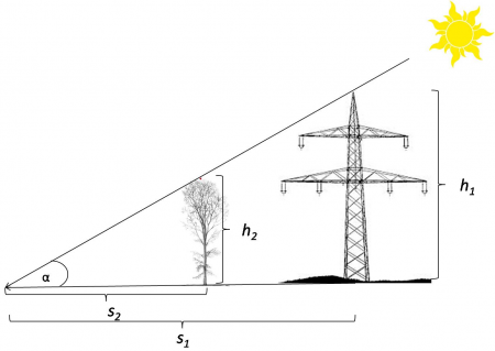
A simple application of the intercept theorem in elementary geometry is to determine the height of a tree by measuring the shadow length. According to Fig. A the shadow length \(s_1\) and the height \(h_1\) of a man-made object such as an overhead line tower were measured on the ground. If the lenght of a tree's shadow \(h_2\) is determined at the same time of the day we are able to compute \(h_2=s_2*\frac{h_1}{s_1}\).
We may also use trigonometry if we know the sun elevation \(\alpha\). The height of a tree is then computed \(h_2=s_2*\tan \alpha\).
Digitizing shadow length and measuring sun azimuth in digital orthophotos
Load and display German Geoadata using QGIS 2.4 following the Exercise: Displaying German Geobasis data (GBD) or load the saved project file .\GBData\display_gbd.qgs where the project coordinate reference system (CRS) is set to ETRS89/UTM32N (EPSG:25832).
- Create a new shapefile layer
- Select Layer --> New --> New Shapefile Layer.
- As layer type, select Line. Click the Specify CRS button and select ETRS89/UTM32N (EPSG:25832).
- To add an attibute:
- For the attribute's name type Class into the Name field of the New attribute section.
- Select Whole number as data type.
- Confirm with Add to attributes list.
- Confirm with OK and enter path and name (e.g. measure_shadow_length.shp) in the following menu.
- Zoom in to the overhead line tower 220kV shown in Fig. A. Click Add feature
 to start digitizing. Simply click at first on the top of the shadow of the tower second add another node in the center of the base of the tower (Fig. B). Finish the line geometry by right-clicking and entering the attributes in the appearing window (just use an increasing number for the ID, and Class = 1 in case of a man-made object).
- Change the display style of the new line. Select the shapefile in the Layers window. Layer --> Properties --> Style --> Single Symbol. Click on "Simple line" and change the Color according to your preferences and increae the Pen width to 0.5.
- Do not forget to save your changes by clicking again the Toggle editing button
 ! Confirm Save to stop editing and save the changes permanently.
- Select Layer --> New --> New Shapefile Layer.
- Measure the sun azimuth at the time of image acquisition
- Install the CadTools plugin using Plugins --> Manage and install plugins.
- We use the "Show azimuth" function of CadTools to calculate the azimuth between two points which have to be selected first. Zoom in to the overhead line tower and the digitized shadow lenght. Activate Select 2 Vertex Points
 and click at first on the node on top of the shadow of the line tower and second on the node near the base of the line tower. Calculate the azimuth by clicking Show Azimuth
  .
.
