Exercise : Measuring heights of trees outside the forest (TOF) in digital orthophotos (DOP)
(→Measuring shadow length) |
|||
| Line 6: | Line 6: | ||
We may also use trigonometry if we know the sun elevation <math>\alpha</math>. The height of a tree is then computed <math>h_2=s_2*\tan \alpha</math> | We may also use trigonometry if we know the sun elevation <math>\alpha</math>. The height of a tree is then computed <math>h_2=s_2*\tan \alpha</math> | ||
| − | ==Measuring shadow length== | + | ==Measuring shadow length and sun azimut in digital orthophotos== |
| + | |||
| + | Load and display German Geoadata using QGIS 2.4 following the [[Exercise: Displaying German Geobasis data (GBD)]] or load the saved project file ''.\GBData\display_gbd.qgs'' where the project coordinate reference system (CRS) is set to ETRS89/UTM32N (EPSG:25832). | ||
| + | |||
| + | # Create a new shapefile layer | ||
| + | ## Select {{mitem|text=Layer --> New --> New Shapefile Layer}}. | ||
| + | ##* As layer type, select {{button|text=Line}}. Click the {{button|text=Specify CRS}} button and select ETRS89/UTM32N (EPSG:25832). | ||
| + | ##* To add an attibute: | ||
| + | ##** For the attribute's name type {{typed|text=Class}} into the {{button|text=Name}} field of the {{button|text=New attribute}} section. | ||
| + | ##** Select {{button|text=Whole number}} as data type. | ||
| + | ##** Confirm with {{button|text=Add to attributes list}}. | ||
| + | ##* Confirm with {{button|text=OK}} and enter path and name (e.g. {{typed|text=measure_shadow_length.shp}}) in the following menu. | ||
==Estimating sun elevation== | ==Estimating sun elevation== | ||
==Calculating individual tree heights== | ==Calculating individual tree heights== | ||
Revision as of 15:04, 15 July 2014
Contents |
Shadows in orthorectified remote sensing images
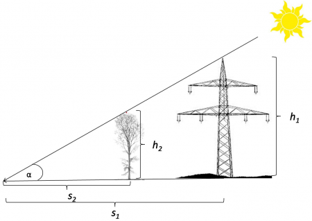
A simple application of the intercept theorem in elementary geometry is to determine the height of a tree by measuring the shadow length. According to Fig. A the shadow length \(s_1\) and the height \(h_1\) of a man-made object such as an overhead line tower were measured on the ground. If the lenght of a tree's shadow \(h_2\) is determined at the same time of the day we are able to compute \(h_2=s_2*\frac{h_1}{s_1}\)
We may also use trigonometry if we know the sun elevation \(\alpha\). The height of a tree is then computed \(h_2=s_2*\tan \alpha\)
Measuring shadow length and sun azimut in digital orthophotos
Load and display German Geoadata using QGIS 2.4 following the Exercise: Displaying German Geobasis data (GBD) or load the saved project file .\GBData\display_gbd.qgs where the project coordinate reference system (CRS) is set to ETRS89/UTM32N (EPSG:25832).
- Create a new shapefile layer
- Select Layer --> New --> New Shapefile Layer.
- As layer type, select Line. Click the Specify CRS button and select ETRS89/UTM32N (EPSG:25832).
- To add an attibute:
- For the attribute's name type Class into the Name field of the New attribute section.
- Select Whole number as data type.
- Confirm with Add to attributes list.
- Confirm with OK and enter path and name (e.g. measure_shadow_length.shp) in the following menu.
- Select Layer --> New --> New Shapefile Layer.
