Creating a multi-band GeoTIFF
From AWF-Wiki
(Difference between revisions)
(→Multiband layers) |
(→Multiband layers) |
||
| Line 6: | Line 6: | ||
# If the processing toolbox is not visible, select {{mitem|text=Processing Toolbox}}. | # If the processing toolbox is not visible, select {{mitem|text=Processing Toolbox}}. | ||
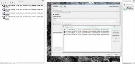
# In the processing toolbar, type {{typed|text=Merge}} into the search field to find the {{button|text=GDAL\OGR --> Merge}} tool and open it ('''figure A'''). | # In the processing toolbar, type {{typed|text=Merge}} into the search field to find the {{button|text=GDAL\OGR --> Merge}} tool and open it ('''figure A'''). | ||
| − | # Click the | + | # Click the button {{button|text=...}} on to select the layers you want to include in the multi-layer band |
[[Image:RemSens_Exercise03_1.png|thumb|left|450px|'''Figure A:''' The ''Merge'' dialogue in [[QGIS]] 2.14]] | [[Image:RemSens_Exercise03_1.png|thumb|left|450px|'''Figure A:''' The ''Merge'' dialogue in [[QGIS]] 2.14]] | ||
[[Category:Working with Raster Data]] | [[Category:Working with Raster Data]] | ||
Revision as of 09:41, 2 May 2016
- In this exercise you will learn how to create composites of several bands of satellite data.
Multiband layers
Satellite image data are most often delivered as single band image files. For displaying colour composites and classification single band image files need to be stacked and saved into a multi-band image:
- Load the different satellite band layers into QGIS. For exercise purposes, you can use Sentinel-2 satellite bands from the directory geodata/Goe/raster/sentinel-2/; the band number is indicated by B and a one- or two-digit number, e.g. B1 for the first band and B2 for the second. Important for producing a correct output multi-band file is that the bands layer are ranked in ascending order in the Layer browser. Usually single bands with the same spatial resolution (GSD or pixel size) are stacked. In case of Sentinel-2 inform on
- If the processing toolbox is not visible, select Processing Toolbox.
- In the processing toolbar, type Merge into the search field to find the GDAL\OGR --> Merge tool and open it (figure A).
- Click the button ... on to select the layers you want to include in the multi-layer band

Figure A: The Merge dialogue in QGIS 2.14