Forest Definition
Contents |
General observations
In large area forest inventories, estimation of forest area is one of the most important results. Forest area is a concept that is easily understood and extremely important in the context of discussion sustainability of the forest development in a region or country. Of course, a forest definition is not necessary for an inventory of forest stands for which up-to-date and accurate maps are available.
Of course, the definition of forest is crucial when deforestation is discussed. Deforestation refers to lands where forest has formerly been. Then it becomes extremely important to use exactly the same unambiguous definitions of forest at both points in time – otherwise, the stated deforestation can not be properly understood.
The definition of forest varies with the context; there are differences in forest definitions from a silviculture, ecology or legal point of view. However, for large area forest inventory, the definition of forest needs to comply with two – some times slightly contradicting – requirements:
- It should be close to the definition used in the National Forest Act viz. in national forest policy processes; and
- it must be operational so that the decision can be made without major complications whether at a defined point there is forest or not. This refers to both data sources: field observations and observations in remote sensing imagery.
The issue of forest definition has been discussed in the forestry, forest policy and forest inventory community for decades and the discussions are likely to continue. A very comprehensive compilation of forest definitions from all parts of the world has been published by Gyde Lund.
Components of a forest definition
When we look at forest definitions, we can clearly distinguish two different classes of criteria: quantitative and qualitative criteria.
Quantitative criteria include measurable thresholds such as minimum area of a “tree cluster” to be called “forest”, minimum width, minimum height of the tree vegetation, minimum crown coverage, and in some countries also minimum productivity (\(m^3/ha\)).
Qualitative criteria include the definition of “tree”, statements how to deal with roads, buildings, timber storage sites and other infrastructure within a forested area, and how to deal with creeks or lakes, with temporary clear-cuts etc... Usually, roads and creeks are included as forest land up to defined maximum width. In many regions it may also be necessary to explicitly exclude some land use systems ‑ such as agroforestry systems ‑ which fulfill many of the “biophysical” criteria of sufficient tree cover, but are obviously not a forest because used for agriculture.
Forest definition of FAO
The FAO definition of “forest” is widely adopted in many national forest inventories and it is the forest definition to which the international forest reporting of FAO refers to. The definition is published as part of the documentation of the Forest Resource Assessment Project within FAO which can be looked up at the FAO´s Forestry Department´s web site in Working Paper 33.
According to the FAO, forest is defined as
- “land with tree crown cover (or equivalent stocking level) of more than 10 percent and an area of more than 0.5 hectares (ha).
- The trees should be able to reach a minimum height of 5 meters (m) at maturity in situ.
- May consist either of closed forest formations where trees of various storey and undergrowth cover a high proportion of the ground or open forest formations with a continuous vegetation cover in which tree crown cover exceeds 10 percent.
- Young natural stands and all plantations established for forestry purposes which have yet to reach a crown density of 10 percent or tree height of 5 m are included under forest,
- as are areas normally forming part of the forest area which are temporarily unstocked as a result of human intervention or natural causes but which are expected to revert to forest.”
This definition includes “forest nurseries and seed orchards that constitute an integral part of the forest; forest roads, cleared tracts, firebreaks and other small open areas; forest in national parks, nature reserves and other protected areas such as those of specific scientific, historical, cultural or spiritual interest; windbreaks and shelterbelts of trees with an area of more than 0.5ha and width of more than 20m; plantations primarily used for forestry purposes, including rubberwood plantations and cork oak stands”, but it excludes “land predominantly used for agricultural practices.”
 Summary
- FAO´s forest definition puts emphasis on tree crown cover of more than 10% and area of more than 0.5ha. Besides that, FAO defines forest according to land use; therefore, any land use with agricultural purpose will not be defined as forest.
 Interesting to know
- Recently there is a lot of discussion in context of the actual climate policy. The question is, whether carbon sequestration of bamboo (as a grass) or palms is eligible and can be accounted as sink in the existing carbon payment schemes. The actual question is whether a forest is defined to consist of trees alone or whether also other plants can constitute forests per definition.
A forest “patch” can be defined for trees that are outside forest but in an agricultural land which has crown cover more than 10% and cover an area more than 0.5ha. When remote sensing is used for classification of forest and non-forest, local knowledge is essential because sometimes, it is hard to distinguish the land use system from images without knowing the area well: grassland with trees may be forest (if the criteria are met) – but if cattle is around it is agriculture (pasture) and can not be forest.
Discussion points referring to forest definitions
The definitions discussed here refer essentially to field measurements or to high resolution remote sensing imagery, where the criteria described above can actually be observed and measured. However, in many forest mapping studies, coarser resolution imagery is being used and the above specified definitions can not be applied, at least not directly. Then, if an interest is there to make the remote sensing based forest mapping compatible with the results of inventory studies that have forest definitions as described above – proxies need to be developed for image classification. Vegetation types are being distinguished in remote sensing imagery mainly from spectral reflectance and image texture. Of course, these criteria can not directly be converted into the above described ones. When comparing forest cover estimates based on field sampling with those based on remote sensing imagery, compatibility of definitions is an important point.
Examples
Example 1: Legal forest definition of Costa Rica
As an illustration how difficult it can be to make a forest inventory definition of “forest” such that it is close to the legal definition. In that Central American country, “forest” is defined for fiscal etc. reasons in the national forest act (Act 3 Ley Forestal No. 7575) as a
- native ecosystem,
- with human interventions or not,
- regenerated through succession or other forest techniques,
- covering an area of 2 or more hectares,
- characterized by the presence of mature trees of different ages, species or aspects,
- with one ore more layers covering more than 70% of the surface area and
- with more than 70 trees per hectare of dbh 15cm or more”.
This definition uses both quantitative and qualitative criteria. If taken literally (and one should take a definition literally …) some of the criteria can only be determined through extensive measurements, such as the required 70 trees per ha that have a dbh of 15cm or more. It is, therefore, hardly possible to use this definition as it is for forest inventories. Adjustments need to be made. And these adjustments may lead to differences also in forest area estimations.
Example 2: Other examples of forest definition
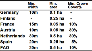
As mentioned before, forest definition varies according to different context. Thus, it varies according to different countries. Table 1 shows forest definitions as used in the national forest inventories of some European countries. Even between neighboring countries there are considerable differences. These differences will, obviously, be the more serious, the more open forest areas (such as swamp forest, forests in dry areas or forests close to the timber line) and small forest patches there are. If only relatively large and closed forest blocks exist, then the differences due to different threshold values of minimum area, minimum width and minimum crown cover affect the estimations only slightly.
When the forest area figures of many countries are to be combined, an algorithm must be found how to harmonize the definitions.
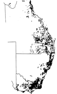
A further illustration is given in Figure 1 where the results of a forest inventory in Australia are depicted. This inventory had been carried out per state. It is noticeable that there is an abrupt change of the spatial arrangement of forest cover at the border between the provinces of Queensland and New South Wales. I see two major possibilities for explanation (without actually knowing more about it): Either there are really different forest spatial distributions (for example as a consequence of differences in forest or agricultural policy between the neighboring provinces); or the differences are due to differences in definition.
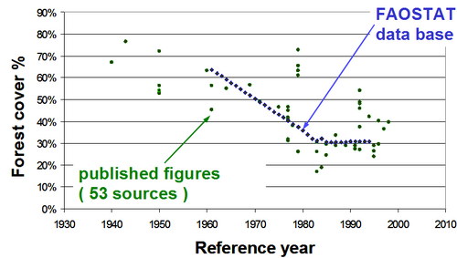
In a study on published forest area figures (Figure 2) for Costa Rica over time Kleinn and Morales (2000[1]) found that while a trend could be found, there were considerably different figures for the same years. These differences were also due to different concepts and definitions of forest; however, also other reasons were found. In earlier times, for example, secondary forest was not considered really forest, because it was seen as largely unproductive. In the 1990, then, secondary forests were included into the forest definition. In another case, it was found that a figure was “potential forest area” but was then cited in another publication as “forest area”!
Figure 2 Comparing published forest cover figures for Costa Rica from different sources (Kleinn and Morales 2002).
 Note
Note
- If you ever need to analyze large area forest inventory results reported by colleagues, it is always one of the first questions to ask, what the underlying definition of forest was for that particular project.
References
- ↑ Kleinn C., L. Corrales, D. Morales. 2002. Large area forest cover estimates in the tropics – the case of Costa Rica. Environmental Assessment and Monitoring, 73(1):17-40.


