Spectral indices
From AWF-Wiki
Vegetation index using the Raster Calculator
- Click the Add raster layer
 and select a multiband Sentinel-2 satellite image
- Check the rank and spectral range of bands in the multiband file (e.g. see table Changing Raster Layer Style).
- After clicking Open, the raster layer appears in the QGIS canvas.
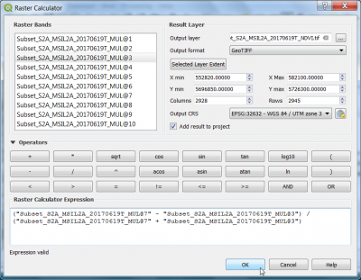
- Click Raster --> Raster calculator.
- A powerful normalization is realized by the normalized difference vegetation index that forms the basis of most vegetation indices $NDVI = (NIR - Red) / (NIR + RED)$. It can be implemented using Raster Calculator as seen in the following screenshot:
