Spatial subset
From AWF-Wiki
- Click the Add raster layer
 and select the file C:/OSGeo4W64/geodata/raster/s2/Subset_S2A_MSIL2A_20170619T.tif.
- After clicking Open, the raster layer appears on the QGIS canvas.
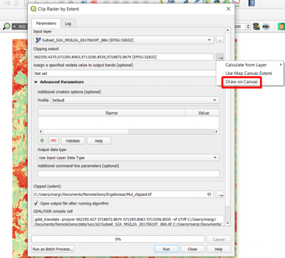
- Raster --> Extraction ---> Clipper...
- Input file (raster): Choose a loaded file name fron the drop down list or click Select to browse to a file.
- Output file: click Select to choose a new file name for the subset image.
- The clipping mode is now already active. Hold a left click on the map canvas dragging a box of your region of interest.
- Adjust the extent coordinates in the text file rounding the coordinates of 1 (upper left corner) x, y and 2 (lower right corner) x, y.
- Click OK.
