Talk:Georeferencing of UAV photos
From AWF-Wiki
(Difference between revisions)
(Created page with "Would be better to create a new page "Organizing your data" ... * Right click on the upper part of the main Qgis menu. In the {{tool|text=Panel}} check the box beside the {{to...") |
Revision as of 12:59, 1 November 2017
Would be better to create a new page "Organizing your data" ...
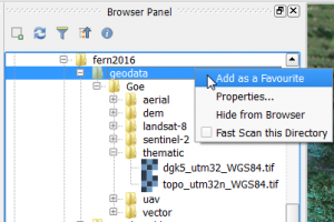
- Right click on the upper part of the main Qgis menu. In the Panel check the box beside the Bowser panel. Drag the Bowser panel window on top of the Layer panel. Browse to your geodata folder where the tutorial data were stored and extracted. Mark geodata and right click Add as a favourite.
 .
.
