Map validation
From AWF-Wiki
(Difference between revisions)
(→Accuracy and area estimation with R) |
|||
| Line 11: | Line 11: | ||
= Accuracy assessment and stratified area estimation with R = | = Accuracy assessment and stratified area estimation with R = | ||
FAO implemented a map validation and stratified area estimation tool based on R, Rstudio and the Shiny package. | FAO implemented a map validation and stratified area estimation tool based on R, Rstudio and the Shiny package. | ||
| − | The method is based on Olofsson et al. 2013, [https://www.google.com/url?sa=t&rct=j&q=&esrc=s&source=web&cd=7&cad=rja&uact=8&ved=2ahUKEwiw0Ki-6e7mAhWGQkEAHSnZAUgQFjAGegQIARAC&url=http%3A%2F%2Freddcr.go.cr%2Fsites%2Fdefault%2Ffiles%2Fcentro-de-documentacion%2Folofsson_et_al._2014_-_good_practices_for_estimating_area_and_assessing_accuracy_of_land_change.pdf&usg=AOvVaw2DZZdNeqmXqzH2-A0R8tDU 2014]) | + | The method is based on Olofsson et al. [https://www.google.com/url?sa=t&rct=j&q=&esrc=s&source=web&cd=1&cad=rja&uact=8&ved=2ahUKEwi3gPrj6u7mAhXJxcQBHTS9BDkQFjAAegQIBBAC&url=http%3A%2F%2Fftp-earth.bu.edu%2Fpublic%2Folofsson%2FEstimation_Workshop_Lima_Aug2014%2FArticles%2FOlofsson_etal_2013_RSE.pdf&usg=AOvVaw02RA0NgxqnikfTSsIckTuU 2013], [https://www.google.com/url?sa=t&rct=j&q=&esrc=s&source=web&cd=7&cad=rja&uact=8&ved=2ahUKEwiw0Ki-6e7mAhWGQkEAHSnZAUgQFjAGegQIARAC&url=http%3A%2F%2Freddcr.go.cr%2Fsites%2Fdefault%2Ffiles%2Fcentro-de-documentacion%2Folofsson_et_al._2014_-_good_practices_for_estimating_area_and_assessing_accuracy_of_land_change.pdf&usg=AOvVaw2DZZdNeqmXqzH2-A0R8tDU 2014]) |
[[Category:QGIS Tutorial]] | [[Category:QGIS Tutorial]] | ||
Revision as of 12:09, 6 January 2020
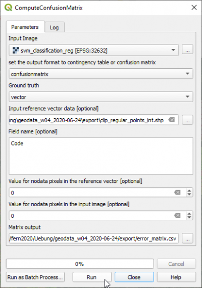
QGIS Processing toolbox with OTB plugin
- Type into the search box of Processing tools Confusion and double click ComputeConfusionMatrix.
- Set the classified map as Input image.
- Select the output file name with the extension .csv under Matrix output.
- The validation data can be in vector or raster format. Select as Ground truth vector.
- Set the validation file CE_2020-01-03.shp as Input reference vector data.
- Set the Field name with the class code valid_clas.
- Click Run.
- Open the CSV output file with Libre Office Calc or MS Excel. Calculate User accuracies, Producer accuracies, Overall accuracy and Kappa index.
Accuracy assessment and stratified area estimation with R
FAO implemented a map validation and stratified area estimation tool based on R, Rstudio and the Shiny package. The method is based on Olofsson et al. 2013, 2014)
