Load a WFS-Layer
From AWF-Wiki
(Difference between revisions)
(→Add a WFS-Layer) |
|||
| (2 intermediate revisions by one user not shown) | |||
| Line 5: | Line 5: | ||
* {{button|text= Web --> WFS 2.0 Client --> WFS 2.0 Client}} | * {{button|text= Web --> WFS 2.0 Client --> WFS 2.0 Client}} | ||
* WFS 2.0 OnlineResource: {{typed|text=https://sgx.geodatenzentrum.de/wfs_clc5_2018}} | * WFS 2.0 OnlineResource: {{typed|text=https://sgx.geodatenzentrum.de/wfs_clc5_2018}} | ||
| − | This is an open data Corine Land cover | + | This is an open data product Corine Land cover 2018 provided by Bundesamt für Kartographie und Geodäsie (BKG) |
* Click {{button|text= GetCapabilities}} | * Click {{button|text= GetCapabilities}} | ||
| − | * Switch checkbox "Use current Extent | + | * Switch checkbox on "Use current Extent as Bounding Box Filter". |
| + | * Click {{button|text= GetFeatures}} for downloading features. | ||
| + | [[File:qgis_WFS_add.png|400px]] | ||
[[Category: Working with Online Data Sources]] | [[Category: Working with Online Data Sources]] | ||
Latest revision as of 14:06, 25 May 2022
Web Feature Service (WFS) is an OGC standard for manipulating vector data. It allows querying (spatial and non-spatial) and retrieval of geographic features.
[edit] Add a WFS-Layer
- Install the WFS 2.0 client plugin in QGIS
- Start QGIS und load a vector polygon of your municipality into the map canvas. Zoom to the vector extent.
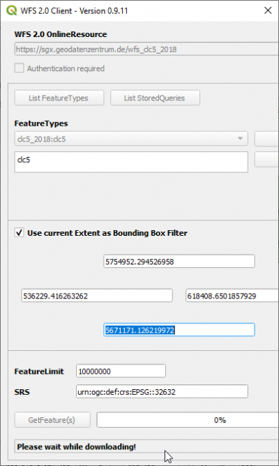
- Web --> WFS 2.0 Client --> WFS 2.0 Client
- WFS 2.0 OnlineResource: https://sgx.geodatenzentrum.de/wfs_clc5_2018
This is an open data product Corine Land cover 2018 provided by Bundesamt für Kartographie und Geodäsie (BKG)
- Click GetCapabilities
- Switch checkbox on "Use current Extent as Bounding Box Filter".
- Click GetFeatures for downloading features.
