Creating new vector layers
From AWF-Wiki
(Difference between revisions)
| Line 1: | Line 1: | ||
| − | |||
# Click the {{button|text=Add raster layer}} in the toolbar or choose {{mitem|text=Layer → Add raster Layer}} | # Click the {{button|text=Add raster layer}} in the toolbar or choose {{mitem|text=Layer → Add raster Layer}} | ||
| − | # Navigate to ''../ | + | # Navigate to the georeferenced DOP ''../geodata_w02/mavic_rgba_modified.tif'' |
# Make sure the “Files of type” drop-down box has the “GeoTiff” filter selected. | # Make sure the “Files of type” drop-down box has the “GeoTiff” filter selected. | ||
| − | |||
| − | |||
| − | |||
# Create a new vector layer. Click {{mitem|text=Layer → New vector layer}}. | # Create a new vector layer. Click {{mitem|text=Layer → New vector layer}}. | ||
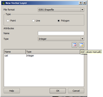
| − | # Prepare the following window as shown below. <br> Type: Polygon <br> Type: text data <br> Name: | + | # Prepare the following window as shown below. <br> Type: Polygon <br> Type: text data <br> Name: species <br> Width: 80 |
You can add additional attributes as columns with the button [[File:Addvaluesmanually.png|25px]]. The values of the attributes can be defined during the digitizing process. | You can add additional attributes as columns with the button [[File:Addvaluesmanually.png|25px]]. The values of the attributes can be defined during the digitizing process. | ||
[[File:Newvectorlayerad.png|400px|center]] | [[File:Newvectorlayerad.png|400px|center]] | ||
Revision as of 12:27, 25 May 2020
- Click the Add raster layer in the toolbar or choose Layer → Add raster Layer
- Navigate to the georeferenced DOP ../geodata_w02/mavic_rgba_modified.tif
- Make sure the “Files of type” drop-down box has the “GeoTiff” filter selected.
- Create a new vector layer. Click Layer → New vector layer.
- Prepare the following window as shown below.
Type: Polygon
Type: text data
Name: species
Width: 80
You can add additional attributes as columns with the button ![]() . The values of the attributes can be defined during the digitizing process.
. The values of the attributes can be defined during the digitizing process.
Save the Layer in your geodata folder, name it train.
