File:3.7-fig44.png

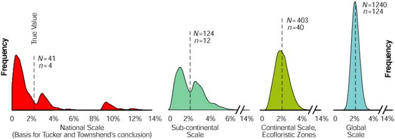
Distribution of sample based estimations of deforestation for Bolivia with 10% sampling intensity. Left: a wide range of estimated deforestation figures is produced when the original 41 Landsat scenes are taken as population. However, when these 41 images are simply 30 times copied (thus generating a much larger population but with exactly the same characteristics like mean and variance), then the 10% sample produces considerably much more precise results!
Reference:
Czaplewski R. 2003. Can a sample of Landsat sensor scenes reliably estimate the global extent of tropical deforestation? International Journal of Remote Sensing 24(6):1409- 1412.
File history
Click on a date/time to view the file as it appeared at that time.
| Date/Time | Thumbnail | Dimensions | User | Comment | |
|---|---|---|---|---|---|
| current | 00:27, 10 March 2011 | 859 × 304 (767 KB) | Aspange (Talk | contribs) | Distribution of sample based estimations of deforestation for Bolivia with 10% sampling intensity. Left: a wide range of estimated deforestation figures is produced when the original 41 Landsat scenes are taken as population. However, when these 41 images |
- Edit this file using an external application (See the setup instructions for more information)
File usage
The following page links to this file: