Measuring slope
| Line 7: | Line 7: | ||
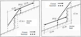
[[File:2.5-fig21.png|left|285px|thumb|'''Figure 1''' Uneven oblique plane as used in Field Manual 2nd Swiss NFI (Brändli ''et al'' 1994<ref name="Brändli1994">Brändli UB, A Herold, H Stierlin und J Zinggeler. 1994. Schweizerisches Landesforst-inventar. Anleitung für die Feldaufnahmen der Erhebung 1993-1995. Birmensdorf, Eidg. Forschungsanstalt für Wald, Schnee und Landschaft. 204 S</ref>).]] | [[File:2.5-fig21.png|left|285px|thumb|'''Figure 1''' Uneven oblique plane as used in Field Manual 2nd Swiss NFI (Brändli ''et al'' 1994<ref name="Brändli1994">Brändli UB, A Herold, H Stierlin und J Zinggeler. 1994. Schweizerisches Landesforst-inventar. Anleitung für die Feldaufnahmen der Erhebung 1993-1995. Birmensdorf, Eidg. Forschungsanstalt für Wald, Schnee und Landschaft. 204 S</ref>).]] | ||
| + | |||
| + | |||
Revision as of 15:21, 18 February 2011
| Attention!: |
This article must be enhanced to meet the AWF-Wiki quality standards! Please visit the Discussion Page of this article for details! |
Slopes in forest inventory are more frequently measured in % than in degrees. Percent slope is determined by the ratio of rise over run; i.e. a 10% slope implies a vertical change of 10 units rise over a distance of 100 units run. For calculations, for example of trigonometric functions, this must be converted to degree or radian with the arctangent function.
Slope angle is measured either with electronic devices or, for example, with the Suunto clinometer. Slope measurement takes place parallel to the terrain inclination. This is straightforward if it is an oblique plain. If the terrain is irregular around the point where the slope angle needs to be measured, then clear rules need to be defined. An example from the Swiss national forest inventory is given in Figure 1.

References
- ↑ Brändli UB, A Herold, H Stierlin und J Zinggeler. 1994. Schweizerisches Landesforst-inventar. Anleitung für die Feldaufnahmen der Erhebung 1993-1995. Birmensdorf, Eidg. Forschungsanstalt für Wald, Schnee und Landschaft. 204 S