Spatial subset
From AWF-Wiki
(Difference between revisions)
(→Interactive box selection) |
(→Masking by vector polygon) |
||
| Line 10: | Line 10: | ||
== Masking by vector polygon == | == Masking by vector polygon == | ||
| − | * Load the vector file | + | * Load the vector file of the communities of county Göttingen e.g. ''\geodata_w01\VG250_GEM_KRS_Goettingen.gpkg''. |
| − | + | * Select a community of your choice: right click {{mitem|text=Open Attribute Table}} | |
| − | * | + | |
| − | + | ||
| − | + | ||
| − | + | ||
| − | + | ||
| − | + | ||
| − | + | ||
| − | |||
| − | |||
* {{mitem|text=Raster --> Extraction ---> Clip Raster by Mask Layer...}} | * {{mitem|text=Raster --> Extraction ---> Clip Raster by Mask Layer...}} | ||
| − | # Input file (raster): Choose a loaded file name from the drop down list or click {{button|text=Select}} to browse to a file | + | # Input file (raster): Choose a loaded file name from the drop down list or click {{button|text=Select}} to browse to a file. * Make sure that the CRS is the same like the image file (here WGS84/UTM Zone 32, EPSG:32632) that you wish to be clipped! |
| − | # Mask layer: Select the | + | # Mask layer: Select the vector file (s. above). |
| + | # Switch checkbox on: '''Selected features only'''. | ||
| + | # Assign a specofied nodata value: {{button|text=65535}} | ||
# Clipped (mask)): click {{button|text=Select}} to choose a new file name for the subset image. | # Clipped (mask)): click {{button|text=Select}} to choose a new file name for the subset image. | ||
# Switch the checkbox on: '''Crop the extent of the target dataset to the extent of the cutline'''. All image data outside the polygon will be masked. | # Switch the checkbox on: '''Crop the extent of the target dataset to the extent of the cutline'''. All image data outside the polygon will be masked. | ||
| − | + | # Click {{button|text=Run}}. | |
| − | + | ||
| − | # Click {{button|text=Run | + | |
[[File:Qgis_raster_mask.png|700px]] | [[File:Qgis_raster_mask.png|700px]] | ||
[[Category: Working with Raster Data]] | [[Category: Working with Raster Data]] | ||
Revision as of 11:38, 13 May 2020
Interactive box selection
- Click the Open Data Source Manager
 and Add raster layer
  and select the file /geodata_w01/mosaic_S2B_MSIL2A_20190724T103029_N0213_R108_T32UNC_UNB_UPC.tif.
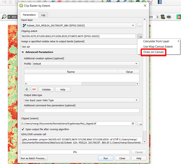
- Raster --> Extraction ---> Clip Raster by Extent
- Input file (raster): Choose a loaded file from the drop down list or click Select to browse for a file.
- Output file: click Select to choose a new file name for the subset image.
- Define the clipping extent by clicking... and Select extent from canvas The clipping mode is now active. Hold a left click on the map canvas dragging a box of your region of interest.
- Adjust the extent coordinates in the text file rounding the coordinates (upper left and lower right).
- Click OK.
Masking by vector polygon
- Load the vector file of the communities of county Göttingen e.g. \geodata_w01\VG250_GEM_KRS_Goettingen.gpkg.
- Select a community of your choice: right click Open Attribute Table
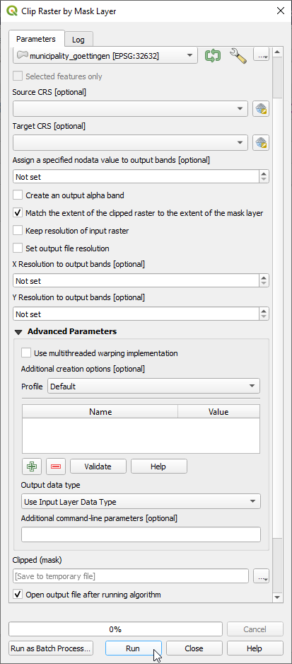
- Raster --> Extraction ---> Clip Raster by Mask Layer...
- Input file (raster): Choose a loaded file name from the drop down list or click Select to browse to a file. * Make sure that the CRS is the same like the image file (here WGS84/UTM Zone 32, EPSG:32632) that you wish to be clipped!
- Mask layer: Select the vector file (s. above).
- Switch checkbox on: Selected features only.
- Assign a specofied nodata value: 65535
- Clipped (mask)): click Select to choose a new file name for the subset image.
- Switch the checkbox on: Crop the extent of the target dataset to the extent of the cutline. All image data outside the polygon will be masked.
- Click Run.

