Exercise: Estimating forest area of county Göttingen based on digital landscape model (DLM) and administrative boundaries 1: 250 000
From AWF-Wiki
Since 2013 the federal government of Germany has published the ordinance to determine the conditions for use and provision of spatial data. A couple of spatial data products are provided free of charge for download or online use by Bundesamt für Kartographie und Geodäsie in Frankfurt (BKG)
Use of digital topographic map 1:250 000 as web map service (WMS)
Digital topographische maps describe topographical objects of the landscape and relief of the earth's surface in raster format.
- Add a WMS dataset. Click
 Add WMS Layer or Layer --> Add Layer --> Add WMS/WMTS Layer. Fill in the connection details. Name: WMS dtk250, URL: http://sg.geodatenzentrum.de/wms_dtk250. Click Connect. Select Layer ID: 01, Name: dtk250. The topographic map 1:250 000 of Germany is loaded (Fig. A). Zoom out to a larger overview.
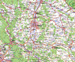 Figure A: Digital topographic map 1:250 000. Source: http://www.bkg.bund.de ©GeoBasis-DE / BKG 2016

Use of digital landscape model and administrative boundaries 1:250 000 as web feature service (WFS)
- Click
 Add WFS Layer and Server connections New. Fill connection details. Name: WFS dlm250, URL: http://sg.geodatenzentrum.de/wms_dlm250. Click Connect. Mark the row with TITLE = OBJART_43002_f01 (Forest). Click Add. Be patient: all forest area objects of Germany are now downloaded as vector polygons. When the download is finished, click Close: the polygons are displayed in the viewer. Full explanation of the object codes and classification scheme can be found in german or english docs.
Examples for modelling classes of feature type Nr. 43002 (forest) are given:
- Click Add WFS Layer and Server connections New. Fill in connection details. Name: WFS vg250, URL: http://sg.geodatenzentrum.de/wfs_vg250. Click Connect. Mark the row with TITLE = Kreis. Add. All county boundaries of Germany are downloaded as vector polygons. Click Close and the polygons are displayed in the viewer. Open the attribute table of layer Kreis by marking the layer name and right click. In the attribute table menu click
 Select features using expression. Type the expression "GEN" = 'Göttingen'. Click
  Move selection to top. The county Göttingen is now selected. Mark layer Kreis in the layer panel. Save as ... Type path and a new file name Landkreis Göttingen and check the box Save only selected features. OK.
Calculating forest area of county Göttingen
- Clip forest area of Germany with county area of Göttingen. Vector --> Geoprocessing Tools --> Clip. Input vector layer = OBJART_43002_f, Clip layer = Landkreis Göttingen. Output shapefile = OBJART_43002_f_clip. OK. (Fig. B).
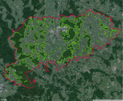 Figure B: Forest area (green diagonal hatch) and county area Göttingen (red) 1:250000 overlaid on Google Satellite layer. Source: http://www.bkg.bund.de ©GeoBasis-DE / BKG 2016
 - Calculate area and perimeter for the clipped forest polygons. Vector --> Geometry Tools --> Export/Add Geometry Columns.
- Calculate the sum of the column AREA in the OBJART_43002_f_clip layer. Vector --> Analysis Tools --> Basic Statistics. Divide the result by the total county area given in column Shape_area of the attribute table of layer Landkreis Göttingen. What is the percentage of forest area in county Göttingen?
